|
|
|
|
|
|
 |
 |
 |
|
|
|
|
Your Price: $ 35.00
Item Number: RM189026
|
|
|
|
|
|
| | We also accept Checks and Money Orders. |
|
|
|
|
|
 |
|
 |
|
|
|
|
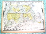
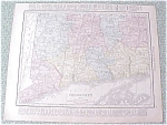
Circa: 1890
Condition: Good+++
Publisher: Rand McNally
Offering this nice old 1890 map of the state of New York on one side and Massachusetts, Connecticutt, and Rhode Island on the other side. This map was published / printed by Rand McNally & Co, 1890. No date is printed directly on the map but it was acquired from the Rand McNally Atlas, published 1890 - this is not a reproduction. Measures 13 3/4 x 10 1/2 inches, good+++ condition, no holes, tears, or stains; light age toning that adds to its charm. Nice colors and details. These old maps look really great matted & framed. A handsome piece of history and unusual art piece for your home or office! Shipping/insurance to any continental US address will be $6.00
|
|
You might also like:
|
|
|


