Click to zoom
Description
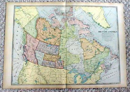
Offering this map of British America (now Canada), dated 1899, by J. Martin Miller, Chicago Illinois. Measures 16 1/4" tall x 22 1/4" wide, good condition, no stains, one tiny 1/2" tear on bottom margin edge, has been mended on backside with archival tape, would not be noticeable when framed, since this is a large map there is a center fold line but is all one piece, not two. This map shows what is now Quebec as lower part as Quebec and upper part as Ungava; Manitoba & Ontario today as a small Manitoba, Ontario and Keewatin; Alberta, Saskatchewan today as Alberta, Assiniboia, Saskatchewan, and Athabasca. Nice colors, these old maps look really great matted & framed. A handsome piece of history for your home or office!
Specifications
| Condition | Good |
| Year Produced | 1899 - 1899 |
| Weight | 1 lbs |
| SKU | MAP157 |
1899 Map British America Canada Antique
$18.00
Shipping calculated at checkout
Fulfillment
Shipping
Caldwell, OH
Estimated Delivery
5-7 business days
Description
Offering this map of British America (now Canada), dated 1899, by J. Martin Miller, Chicago Illinois. Measures 16 1/4" tall x 22 1/4" wide, good condition, no stains, one tiny 1/2" tear on bottom margin edge, has been mended on backside with archival tape, would not be noticeable when framed, since this is a large map there is a center fold line but is all one piece, not two. This map shows what is now Quebec as lower part as Quebec and upper part as Ungava; Manitoba & Ontario today as a small Manitoba, Ontario and Keewatin; Alberta, Saskatchewan today as Alberta, Assiniboia, Saskatchewan, and Athabasca. Nice colors, these old maps look really great matted & framed. A handsome piece of history for your home or office!
Specifications
| Condition | Good |
| Year Produced | 1899 - 1899 |
| Weight | 1 lbs |
| SKU | MAP157 |