Click to zoom
Description
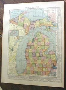
Offering this 1904 C S Hammond map of the state of Michigan on one side and Illinois on the other side. This map was printed by C S Hammond & Co, New York, 1904. Measures 13 1/2" x 10 1/4" (actual map size is 8" X 11"), good condition, no holes or tears; a couple faint spots on margin that will not show when matted & framed, does not affect map, great details and very nice colors. These look really nice framed. This would be a wonderful gift!
Specifications
| Condition | Good |
| Year Produced | 1904 - 1904 |
| Weight | 1 lbs |
| SKU | MAP196 |
1904 Map Michigan And Illinois
$25.00
Shipping calculated at checkout
Fulfillment
Shipping
Caldwell, OH
Estimated Delivery
5-7 business days
Description
Offering this 1904 C S Hammond map of the state of Michigan on one side and Illinois on the other side. This map was printed by C S Hammond & Co, New York, 1904. Measures 13 1/2" x 10 1/4" (actual map size is 8" X 11"), good condition, no holes or tears; a couple faint spots on margin that will not show when matted & framed, does not affect map, great details and very nice colors. These look really nice framed. This would be a wonderful gift!
Specifications
| Condition | Good |
| Year Produced | 1904 - 1904 |
| Weight | 1 lbs |
| SKU | MAP196 |