Click to zoom
Description
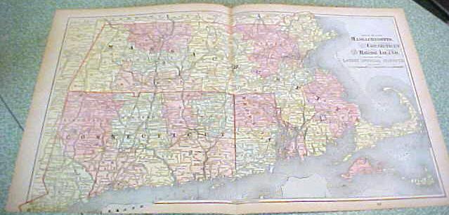
Offering this handsome colored 1894 large foldout map of the states of Massachusetts, Connecticut, and Rhode Island - on the backside are maps of Boston Massachusetts and the states of Vermont & New Hampshire. This map was published / printed by The C.A.Gaskell Family & Business, Atlas of the World; John F Waite, Chicago, IL 1894. No date is printed directly on the map but it was acquired from the C.A. Gaskell Atlas, published 1894 - this is not a reproduction. Measures 13 1/2 x 22 inches, good+++ condition, no holes, tears, or stains; light age toning that adds to its charm. Nice colors and details. These old maps look really great matted & framed. A handsome piece of history and unusual art piece for your home or office! Shipping/insurance to any continental US address will be $6.00
Specifications
| Condition | Good |
| Year Produced | 1894 - 1894 |
| Weight | 1 lbs |
| SKU | GASK103 |
Map Massachusetts Connecticutt Rhode Island 1894 Foldout
$45.00
Shipping calculated at checkout
Fulfillment
Shipping
Caldwell, OH
Estimated Delivery
5-7 business days
Description
Offering this handsome colored 1894 large foldout map of the states of Massachusetts, Connecticut, and Rhode Island - on the backside are maps of Boston Massachusetts and the states of Vermont & New Hampshire. This map was published / printed by The C.A.Gaskell Family & Business, Atlas of the World; John F Waite, Chicago, IL 1894. No date is printed directly on the map but it was acquired from the C.A. Gaskell Atlas, published 1894 - this is not a reproduction. Measures 13 1/2 x 22 inches, good+++ condition, no holes, tears, or stains; light age toning that adds to its charm. Nice colors and details. These old maps look really great matted & framed. A handsome piece of history and unusual art piece for your home or office! Shipping/insurance to any continental US address will be $6.00
Specifications
| Condition | Good |
| Year Produced | 1894 - 1894 |
| Weight | 1 lbs |
| SKU | GASK103 |