
Click to zoom
Description
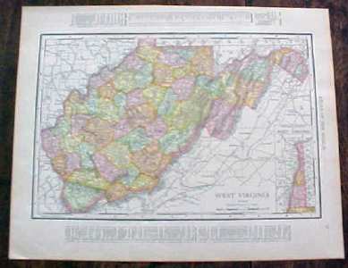
Offering this nice old 1912 map of the state of West Virginia on one side and the state of North Carolina on the other side. This map was published / printed by Rand McNally & Co, 1912; copyrighted 1911. Measures 14 1/4 x 11 1/2 inches, good+ condition, no holes, tears, or stains, light age toning which adds to its charm. Nice colors and details. These old maps look really great matted & framed. A handsome piece of history for your home or office!
Specifications
| Condition | Good |
| Year Produced | 1912 - 1912 |
| Weight | 1 lbs |
| SKU | RM191257 |
Map West Virginia North Carolina 1912
$16.15
Shipping calculated at checkout
Fulfillment
Shipping
Caldwell, OH
Estimated Delivery
5-7 business days

Description
Offering this nice old 1912 map of the state of West Virginia on one side and the state of North Carolina on the other side. This map was published / printed by Rand McNally & Co, 1912; copyrighted 1911. Measures 14 1/4 x 11 1/2 inches, good+ condition, no holes, tears, or stains, light age toning which adds to its charm. Nice colors and details. These old maps look really great matted & framed. A handsome piece of history for your home or office!
Specifications
| Condition | Good |
| Year Produced | 1912 - 1912 |
| Weight | 1 lbs |
| SKU | RM191257 |